Australia is one of the world's great road trip destinations. Its sheer scale — it would take several weeks to drive across without stopping — combined with the variety of landscapes it contains makes it ideally suited to travel by car or campervan. Driving gives you the freedom to stop at places that don't appear in any guidebook, to slow down through small towns that deserve more attention than most itineraries allow, and to experience the shifting qualities of Australian light across a long day's drive.
This guide covers five of Australia's most rewarding road journeys — from the dramatic coastal scenery of Victoria's Great Ocean Road to the raw geological grandeur of the Red Centre. Each route is described with practical information on distances, timing, and the key places worth stopping for. Australian driving conditions and road safety notes are covered at the end of the guide.
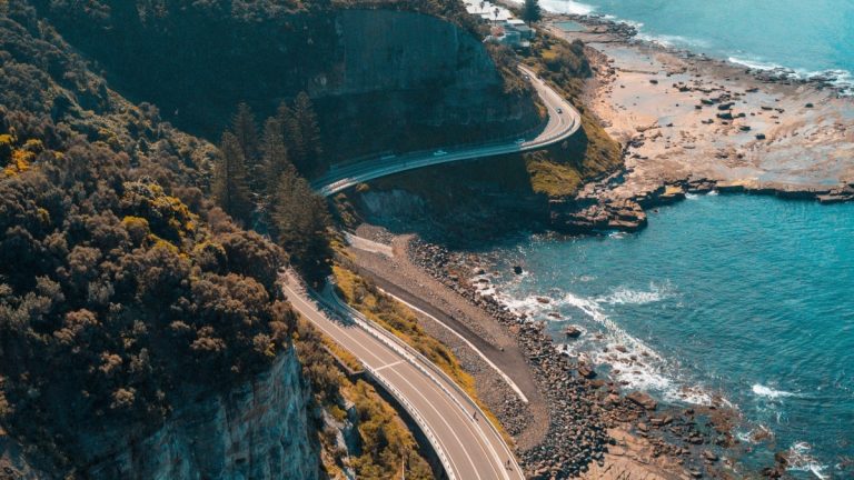
Route 1: The Great Ocean Road, Victoria
Distance: Approx. 243 km (Torquay to Allansford)
Ideal duration: 3–5 days
Best season: Year-round; spring (September–November) for green hillsides
The Great Ocean Road is Australia's most celebrated coastal drive and one of the world's most scenic highway routes. Built between 1919 and 1932 by returned servicemen as a memorial to those who died in World War I, the road hugs the dramatic coastline of southwest Victoria for 243 kilometres, passing through surf towns, national park sections, and inland rainforest gorges before reaching the limestone stacks of the Port Campbell National Park.
Key Stops Along the Route
Torquay and Bells Beach: The journey conventionally begins at Torquay, the surf capital of Australia and home to the Surfworld Museum. Bells Beach, a short drive south, hosts the annual Rip Curl Pro and is one of the most famous surf breaks in the world. Non-surfers can watch from the clifftop lookout.
Lorne: A well-established resort town with a beautiful beach, excellent restaurants, and the popular Erskine Falls walk through tall eucalyptus forest nearby. Lorne fills up on summer weekends — arriving on a weekday makes for a considerably calmer experience.
Apollo Bay: A working fishing harbour surrounded by the Otway Ranges, Apollo Bay is the point where many travellers turn north into the Great Otway National Park. The Otway Fly Treetop Walk — a steel walkway 25 metres above the forest floor among myrtle beech and mountain ash trees — is worth the detour.
The Twelve Apostles: Eight limestone stacks (the number has declined over time as the erosive Southern Ocean continues its work) rising from the sea at Port Campbell National Park are the emotional climax of the Great Ocean Road. The light at sunrise and sunset transforms the stacks from limestone brown to a warm amber — arriving outside the peak midday hours is advisable both for photography and for managing the crowds that this site attracts.
Loch Ard Gorge: Named after a ship that wrecked here in 1878, the gorge is a narrow channel of remarkably blue water enclosed by towering limestone cliffs. Two survivors of the shipwreck were rescued at this spot — information that lends the beautiful scenery an additional weight of history.
The Great Ocean Road was built by human hands as an act of memorial. Driving it slowly, as it deserves, is a form of respect for both the landscape and the history embedded in its construction.
Route 2: The Red Centre Way, Northern Territory
Distance: Approx. 1,138 km (Alice Springs circuit)
Ideal duration: 5–7 days
Best season: May to September (avoid summer heat)
The Red Centre Way is a loop route from Alice Springs that takes in the most significant geological and cultural landmarks of Australia's central desert. It is not a journey for those seeking comfortable, predictable travel — sections of the route involve unsealed roads, long distances between fuel stops, and extreme temperatures for much of the year. But for those prepared for it, the Red Centre Way offers an experience of the Australian interior that is genuinely unlike anything else in the country.
Alice Springs: The Red Centre Base
Alice Springs sits roughly at the geographic centre of Australia, 1,500 kilometres south of Darwin along the Stuart Highway. It is the gateway to the Red Centre and worth spending a day or two before heading out on the circuit. The Alice Springs Desert Park, on the western edge of town, provides an excellent introduction to the ecology of the central desert, with guided tours that explain the relationships between Aboriginal culture and the desert environment.
The Telegraph Station Historical Reserve, north of the town centre, preserves the original 1872 telegraph repeater station that connected Australia to the rest of the world's communication network — a significant moment in the country's history that Alice Springs residents understand well.
West MacDonnell Ranges
The West MacDonnell Ranges extend 160 kilometres west of Alice Springs and contain some of the most beautiful gorge scenery in central Australia. Ellery Creek Big Hole, Ormiston Gorge, and Glen Helen Gorge all offer swimming holes (water temperature varies considerably by season), Aboriginal rock art sites, and short to multi-day walks through dramatic quartzite gorge country. The Larapinta Trail — a 223-kilometre walk from Alice Springs to Mount Sonder — passes through this landscape and is considered one of the best long-distance walks in Australia.
Uluru and Kata Tjuta
The route eventually reaches Uluru, described in our main destinations guide, and the adjacent Kata Tjuta formation. The drive between Alice Springs and Uluru (450 kilometres along the Lasseter Highway) passes through increasingly flat, red-soiled spinifex country — a landscape that is striking in its emptiness and tends to adjust visitors' sense of distance and scale in ways that remain with them.
Kings Canyon
Kings Canyon, reached via the Ernest Giles Road, presents a different kind of geological drama from Uluru. The canyon walls rise 270 metres from the floor of a narrow gorge, and the Rim Walk — a 6-kilometre loop that traverses the canyon's upper edge — provides extraordinary views across sandstone domes eroded into formations known locally as the Lost City. The walk should be started before 9 AM during summer months to avoid dangerous heat exposure on the exposed sections.
Route 3: The Pacific Coast Drive, New South Wales to Queensland
Distance: Approx. 1,700 km (Sydney to Cairns)
Ideal duration: 14–21 days
Best season: Year-round with regional variation
Australia's Pacific Coast Drive — following the Pacific Highway and its coastal alternatives north from Sydney through New South Wales into Queensland, continuing all the way to Cairns — is among the longest coastal road journeys in the world. Few people complete it in its entirety, but driving sections of it provides access to some of eastern Australia's most appealing beach towns, national parks, and coastal scenery.
Northern New South Wales
The section between Sydney and the Queensland border is consistently underestimated. Port Stephens, two hours north of Sydney, is a large estuary with white sand dunes and reliable dolphin sightings. Byron Bay, the most easterly point of the Australian mainland, has evolved from a quiet surf town into one of the most visited destinations on the east coast, but retains enough genuine character to justify a stop of two or three days.
Inland from the Pacific Highway in northern New South Wales, the Dorrigo and New England National Parks protect substantial remnants of subtropical rainforest — a landscape dramatically different from the coast and often overlooked by travellers keeping to the highway.
Queensland's Sunshine and Gold Coasts
Crossing into Queensland, the Sunshine Coast — particularly Noosa Heads — offers a more refined version of the beach town experience than the commercialised Gold Coast to the south. Noosa National Park, a compact coastal park of pandanus forests and headland walks, is accessible directly from the town and provides wildlife sightings (koalas in the trees, sea turtles in the bay) that feel surprisingly easy for a location this close to a popular resort.
Route 4: The Gibb River Road, Western Australia
Distance: Approx. 660 km (Derby to Kununurra)
Ideal duration: 7–10 days
Best season: April to October (road is closed during wet season)
The Gibb River Road traverses the heart of Western Australia's Kimberley region — arguably the most remote and spectacular road journey in Australia that does not require a specialist four-wheel-drive expedition. The road connects Derby on the western end to Kununurra in the east, passing through cattle station country and the ancient gorges of the Kimberley Plateau.
Bell Gorge, Manning Gorge, and El Questro Gorge are the most popular stopping points, each offering swimming holes of extraordinary clarity set beneath tiered rock formations. The Kimberley's geology is among the oldest exposed rock on Earth — formations here date to over 1.8 billion years — and the scale and colour of the landscape (rust-red gorges, cobalt-blue sky, dry savanna grasslands) is like nothing in the eastern states.
Route 5: The Savannah Way, North Australia
Distance: Approx. 3,700 km (Cairns to Broome)
Ideal duration: 21–30 days
Best season: May to September
For those with time and appetite for a genuine outback crossing, the Savannah Way traverses the full width of northern Australia from Cairns in Queensland to Broome in Western Australia. This is not a beginner's road trip — long sections are unsealed, fuel and water management require planning, and mechanical issues in remote areas carry real consequences. But for travellers who approach it with appropriate preparation, the Savannah Way provides access to parts of Australia that relatively few international visitors reach.
Practical Notes for Driving in Australia
Australia drives on the left, as in the UK and Japan. Speed limits on highways are generally 100–110 km/h. In the outback and on unsealed roads, driving at the posted limit is often inadvisable — road conditions vary enormously and can change with weather events. Kangaroos are most active at dawn and dusk and are a genuine road hazard in rural and regional areas; reducing speed in these periods reduces risk significantly.
Fuel availability is an important planning consideration in remote areas. Checking the distance to the next service station before leaving any regional town is not overcautious — it is essential. The Royal Automobile Club of each state maintains current information on service station locations and road conditions. Mobile phone coverage disappears quickly outside major centres and highway corridors; in truly remote areas, a satellite communicator is worth considering for safety.
The experience of driving in Australia — particularly in the outback — is distinctive partly because of the roads' emptiness. Crossing long sections of flat, red, largely unvarying terrain for hours at a time is not for everyone, but it produces a particular quality of attention to landscape and light that cannot be replicated by air. The horizon seems further away than it does anywhere else. The sky feels larger. These are not small things.